|
|
| |
|
|
|
|
| |
Cathedral Grove, British Columbia |
|
|
|
| |
|
|
|
|
| |
Our Big Tree Heritage |
|
Ancient Forest Extermination |
|
| |
Linking Two Biospheres |
|
Protecting Park Values |
|
| |
|
|
|
|
| |
|
|
| |
|
|
|
|
| |
Protecting Park Values
The short colonial history of the Canadian province of British Columbia (BC) is dominated by massive resource extraction. Environmentalists have had to fight every inch of the way to establish parks but even these small refuges of wild nature suffer gross violations. Among the most famous and best loved parks in BC are Cathedral Grove, Goldstream Park and Stanley Park. All face encroachment and the resulting habitat destuction that seems endemic to colonial society. Cathedral Grove is a small and endangered ancient fir forest located on Vancouver Island. It is part of Macmillan Provincial Park, cynically named after one of the most notorious 20th century industrial destroyers of primaeval forests. Right: protest sign erected in 2008 against yet another government assault on the ecological integrity of Cathedral Grove. |
|
 Protest at Cathedral Grove, 18 March 2008.
Photo: Richard Dean |
|
| |
|
|
 |
|
| |

"Murrelet Nesting" by Gary A. Bloomfield, 2003.
Interpretive sign, Headwaters Forest, California |
|
On 19 March 2008 members of the Friends of Cathedral Grove and other concerned citizens protested against plans to close the park for the purpose of demolishing a number of selected trees. Demolition crews were sent in by the BC government to remove the trees, some of them by using dynamite to blow off their tops. Protestors oppose this heavy handed and semi secretive management style conducted by officials who know that it is an ecological violation to cut down trees and destroy habitat in a protected park during bird nesting season. Species that nest in the ancient forest canopy such as the Marbled Murrelet (left) are rare today because of widespread habitat destruction. One of the last recorded Murrelets was seen in 1998 in the vicinity of Goldstream Park. To preserve such endangered species it is imperative that ancient forest biodiversity and parks be given the highest degree of protection. |
|
| |
|
|
|
|
| |
Cathedral Grove and Goldstream Park are managed by "BC Parks," a division of the BC Ministry of Environment. While the government places a high priority on resource exploitation and infrastructure development, environmental issues are greenwashed and sidelined. Even though BC's public parks generate major economic revenue through wilderness and nature tourism, drawing visitors from around the world, government funding for park protection has been decreased and cut back. This failure to preserve biodiversity and uphold wilderness values in BC's public parks goes hand in hand with privatization, as the parks are relentlessly exploited for industrial profit.
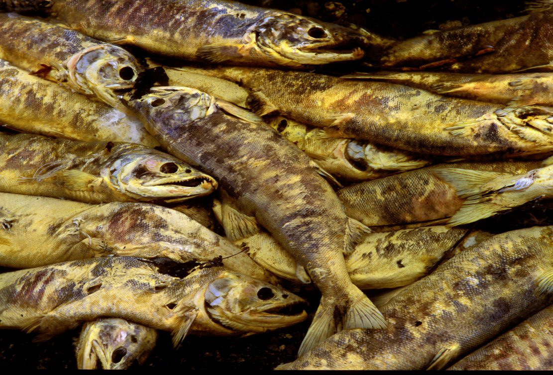
Fewer than six percent of the biggest trees growing in valley bottom ancient temperate rainforests on Vancouver Island are protected in parks; the rest is at the brink of extermination as old growth destruction by the international logging industry continues apace. One of the most popular and heavily used parks in BC is Goldstream Park, located only 16 km from the Provincial Legislature in Victoria. Goldstream Park is a forest remnant on an estuary at the mouth of Goldstream River. This is a spawning grounds for salmon who come to lay their roe and die (below), attracting hundreds of Bald Eagles to feed on the corpses (right).

Spawned salmon, Goldstream River, 2008.
Goldstream Provincial Park, Vancouver Island
|
|

Eagle, Goldstream Park, 1 January 2008.
Photo: Orcawizard
Goldstream Park is part of the rich "Coastal Douglas Fir Biogeoclimatic Zone" which produces magnifent big trees, some of the largest in the world. Due to rampant 20th century industrial destruction, less than one percent of this habitat remains on Vancouver Island. Goldstream Park protects endangered species of flora and fauna and helps to preserve the salmon runs of Goldstream River. The much loved public park also educates thousands of school children each year and is Victoria's most popular tourist attraction. Goldstream Park's popularity is evident in photo sharing websites such as Flickr, with high quality nature photography (left and below). If a fee were charged for taking such photos, ample funds would be available for habitat preservation. |
|
| |
|
|
|
|
| |

"Big Trees, Not Big Stumps," Goldstream Park.
Vancouver Island, British Columbia |
|
The BC government uses nature photography to greenwash its real identity as an industrial plunderer and degrader of BC's valuable natural resources. Its entrenched colonial mindset began with the European settlers whose sole aim was to profit from the bountiful indigenous lands they invaded and stold. First they eradicated the intact coastal forests of California, then they set up a powerful timber industry that moved progressively north, demolishing the lucrative old growth along the way – to Oregon, Washington, BC and Alaska.
Rare native big tree stands survive in protected areas such as Cathedral Grove, Goldstream Park and Stanley Park. All three were encroached on by settlers and logged prior to becoming parks. The photo entitled "Big Trees, Not Big Stumps" (left) was commented on: "sad to think how amazing it must have been before it was cut." |
|
| |
|
|
|
|
| |
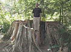
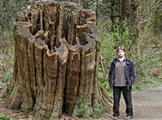
A huge cedar stump relic with deep notches made by early loggers can still be seen in Vancouver's Stanley Park (left). Because the big trees spread widely at the base, such notches were chopped into either side of the stem about five feet above the ground. Springboards, shaped like fan blades, were then inserted to give the tree fallers a platform on which to stand and swing their axes. Often two fallers stood on either side and used a cross saw to cut into the heartwood of the big tree and cause its collapse.

Giant stump from logged ancient cedar tree.
Cathedral Grove, Vancouver Island |
|

Giant cedar stump, with logging scars.
Stanley Park, City of Vancouver
In Cathedral Grove, one of the sights along the path that meanders through the big trees is the "Giant's Grave" (left). From the patronizing BC Parks sign in front of the cedar stump: The "Giant's Grave" interpretive sign (above) puts the focus on a single irresponsible individual while ignoring the devasting vandalism of logging corporations and the deforestation caused by the wood products industry.
This giant red cedar once stood 71 m (233 ft) tall and 4.5 m (15 ft) in diameter. Vandals set it aflame in 1972, ending its 700 year life. It was cut down because the flames were so intense it was feared the fire would spread throughout the park. This tree is an example of our often careless attitude to our forests. It now lies in a self-dug grave created by the force of the impact, a grim reminder of vandalism. |
|
| |
|
|
|
|
| |

Volvo smashed by a blowdown tree, 2008.
Stanley Park, Vancouver, British Columbia
mmmmmmmm |
|
mmmmmmmmmmm
mmmmmm
mmmmm
mmmm.
mmm |
|
| |
|
|
|
|
| |
|
Encroaching on Three BC Parks |
I
Cathedral Grove
134 hectares (332 acres)
Provincial Park, est. 1944
c. 1 million visitors per year |
II
Goldstream Park
335 hectares (828 acres)
Provincial Park, est. 1958
c. 2 million visitors per year |
III
Stanley Park
404.9 hectares (1,000 acres)
Municipal Park, est. 1888
c. 8 million visitors per year |
 |
 |
 |
|
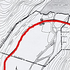
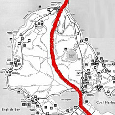
Bisected by the Alberni Highway |
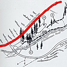
Bisected by the TransCanada Highway |
Bisected by the Park Causeway |
 |
 |
 |
|
Cathedral Grove – Alberni Highway
|
Goldstream Park – TransCanada Highway
|
Stanley Park – Park Causeway |
 |
 |
 |
|
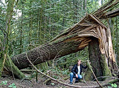
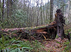
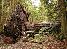
Cathedral Grove – Blowdown |
Goldstream Park – Blowdown |
Stanley Park – Blowdown |
 |
 |
 |
|
Cathedral Grove – Logged Stump |
Goldstream Park – Logged Stump |
Stanley Park – Logged Stump |
|
|
| |
|
|
|
|
| |
The disregard for nature protection by federal, provincial and civic governments is evident even in the protected enclaves of Cathedral Grove, Goldstream Park and Stanley Park. All three parks are cut in half by roads, railways and ever expanding highways that further fragment and degrade the forest habitat: see maps and photos in the Gallery (above). Such thoroughfares open up the already compromised forest remnants to powerful Pacific storms; the ecological damage is manifested by the increasing number of big trees that succumb to the gale force winds and topple over. See the carved stump of one huge cedar tree that was blown down in Stanley Park in 2006 (right).

Ancient big tree, Goldstream Provincial Park.
Vancouver Island, British Columbia |
|

Carved cedar stump, Stanley Park, 2008.
City of Vancouver, British Columbia
Experts in global climate change are calling for an urgent halt to the destruction of old growth forests, to retain their carbon storage benefits. However, if an advanced industrial nation such as Canada cannot prevent the destruction of its last ancient temperage rainforests, then there is little hope for responsible action elsewhere in the world. In BC, some 16 km from the Parliamentary Building in Victoria, the beloved big trees of Goldstream Park (left) are at risk due to government sanctioned urban sprawl which is encroaching on the watershed: mountain tops are blasted off for golf courses and housing tracts, forest buffers are destroyed and so on. |
|
| |
|
|
|
|
| |

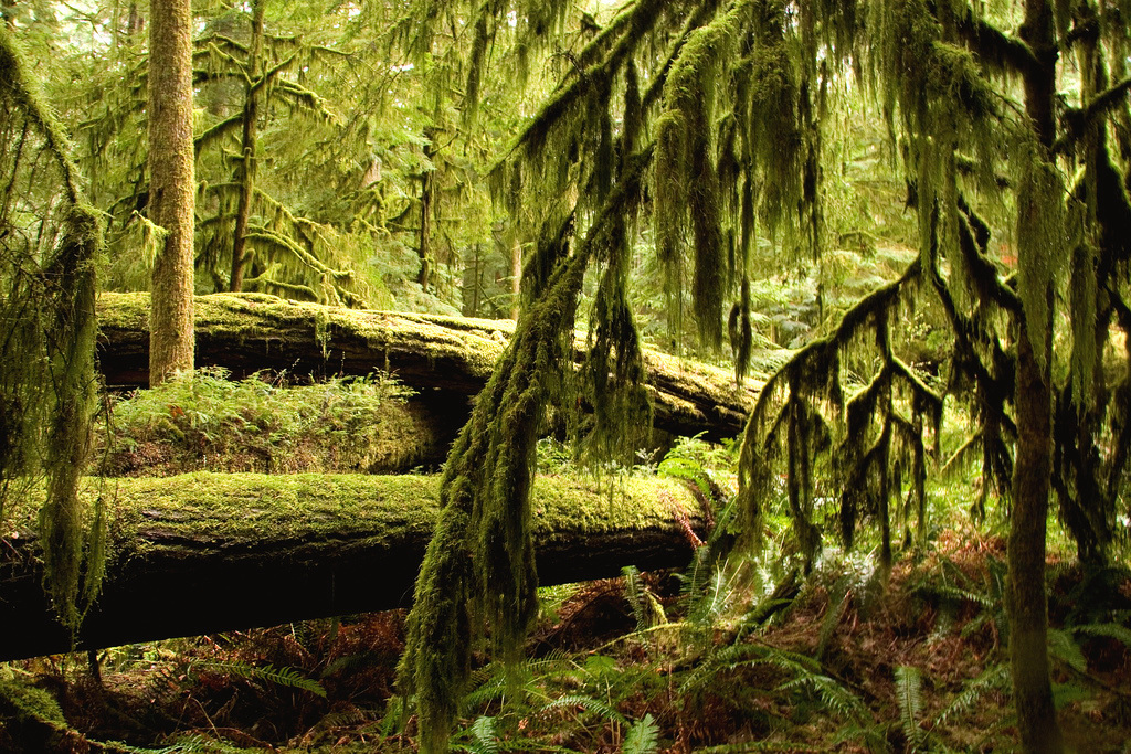
Ancient temperate rainforest.
Cathedral Grove, Vancouver Island, British Columbia |
|
Beyond the viewscapes of Vancouver Island seen from the highways, industrial tree plantations and second growth forests have transformed the once luxurious temperate rainforest into checkered cutblocks harvested on a 40 year rotation basis. Through murky land grabs by railroad and timber barons, Cathedral Grove became part of H. R. MacMillan's timber holdings (left). When it was founded in 1944 as "MacMillan Provincial Park," the 330 acre (136 hectare) park was calculated to contain some 25,000,000 board ft of lumber. |
|
| |
|
|
|
|
| |

Cedar blowdown, 2008.
Cathedral Grove, Vancouver Island, British Columbia |
|
The giant trees of Cathedral Grove extend only a few hundred metres on either side of the highway before the terrain rises steeply. The steep hillsides create a wind funnel by compressing the prevailing wind from the West Coast through the narrow valley corridor. Without a buffer, the trees are subjected to severe wind velocities, causing tops to snap off and stems to break (left).
Big Trees Destroyed The giant Douglas firs and red cedars that inhabit Cathedral Grove were the focus of the first BC environmental fight to challenge the logging industry's presumed "right" to ravage nature. Yet the best efforts of many dedicated activists over decades has not resulted in legislation to protect the rapidly vanishing big trees by making illegal the commercial plundering of this irreplaceable natural heritage. |
|
| |
|
|
|
|
| |
 |
|
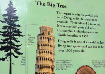
Sign in Cathedral Park: The Big Tree "The largest tree in the park is this giant Douglas fir. It is over 800 years old, 76 m tall and 9 m round. It was over 300 years old when Christopher Columbus came to North America in 1492. Douglas fir is one of Canada's oldest living tree species and can live to be over 1000 years old." |
A BC Parks interpretive sign in Cathedral Grove (above) tributes the "Big Tree" (right) by comparing its 76 m (250 ft) height to the Leaning Tower of Piza at 58 m. Unlike ancient architectural monuments in Europe, however, BC's big tree heritage is not protected. During the past decade, the BC Ministry of Environment and BC Parks have been subjected to crippling cutbacks in government funding. Park budgets, park jobs and park nature education programmes have been slashed; environmental laws have been squashed; and the BC Forest Practices Code has been sabotaged. |
|

The "Big Tree," over 800 years old.
Cathedral Grove, Vancouver Island
|
|
| |
|
|
|
|
| |
Another BC Parks sign describes the "Big Tree" as "already 300 years old
when Columbus reached America in 1492!" See:
Tree–mendous! This tribute is followed by a comparison of its great size in relation to its commercial value as timber and as wood products: "It has 26 board feet of lumber which could build two two storey, four–bedroom houses."
Friends of Cathedral Grove (FROG) The grassroots environmental and nature protection group FROG is dedicated to protecting the biodiversity of the big tree habitat. This includes keeping watch to prevent further degradation of the Cathedral Grove Watershed by logging corporations; Island Timberlands and its predecessors: Weyerhaeuser, MacMillan Bloedel, et al. FROG formed after community outrage peaked when Weyerhaeuser logged right up to the boundaries of Cathedral Grove in several large swatches, leaving the big trees vulnerable to blowdown (left). The notorious American tree killing company also blasted logging roads across the Cameron River floodplain, causing permanent drainage damage. |
|

Kids on an uprooted ancient cedar tree.
Cameron River, Cathedral Grove
|
|
| |
|
|
|
|
| |

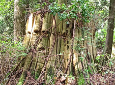
Culturally modified trees, Cathedral Grove.
Photo: Ingmar Lee |
|
Ancient Forest Extermination Cathedral Grove is a living "Heritage Forest" with culturally modified trees (left) requiring urgent protection, yet the vulnerable forest continues to be logged in 2009 by Island Timberlands. Logging corporations have no regard for the indigenous people who managed the Cathedral Grove Watershed so well that it flourished for thousands of years. Grabbed by greedy colonizers, the forest lands were taken over by corporations using devious tactics and called "Private Forestlands."
Cathedral Grove is inhabited mostly by enormous Douglas fir veteran trees. These exceptionally tall trees were not long ago abundant but their value as timber caused them to be exploited to ruination by the wood products industry. As a rare surviving example of the arboreal magnificence which we have lost, Cathedral Grove continues to serve BC as a world class tourism attraction (below). |
|
| |
|
|
|
|
| |

Cathedral Trail sign and historical plaque about the Scottish
botanist for whom the Douglas fir species is named.
Cathedral Grove (Macmillan Provincial Park) Vancouver Island, British Columbia |
|
| |
|
|
|
|
| |

Goldstream Park, Victoria, British Columbia.
Photo: Nicolas Saunier | |
One of the first watersheds to be desecrated following the colonization of Vancouver Island since 1858, was that of the Goldstream River, beginning with the discovery of gold in the 1860s. Because of its close vicinity to Fort Victoria, the Goldstream Watershed was early on exploited for mining, logging, and fishing. Further degradation followed the Dunsmuir Land Grab of 1883 and the colonial expansion of power plants, railways, highways and urban sprawl.
Goldstream River (left) was dammed in 1892 to supply the colonial capital, Victoria, with water. An hydro plant was built in 1895 which operated until 1958, when the provincial park was founded. Yet it took another 40 years, until 1998, for environmentalists to finally succeed in forcing the government to stop clearcut logging in the Goldstream Watershed. The cumulative effect of habitat degradation resulted in the near extinction of the wild salmon native to the Goldstream River. |
|
| |
|
|
|
|
| |
The Coast Salish peoples have stewarded the salmon and forest resources for millenia. The mouth of Goldstream River is at the head of a long fjord known as the Saanich Inlet after the Coast Salish Peoples. Few visitors to Goldstream Park realize that it is the site of an ancient indigenous village and burial ground, as well as an important chum salmon fishery. Only in 1913 did the government allot a small and inadequate 12 acre parcel of land to the five Saanich tribes and land owners (Malahat, Pauquachin, Tsartlip, Tsawout and Tseycum), called Goldstream Indian Reserve No. 13.
SPAET "Skirt Mountain" is a colonial misnomer for SPAET, . a high ground traditional hunting and gathering area that is part of the Goldstream Watershed. In the past four years, SPAET has been violated, its mountain top blasted off by a rapacious development corporation called the Bear Mountain Resort. Tsawout Hereditary Chief Eric Pelkey (right), spokesperson for the Sencot'en Alliance, demonstrated in 2008 against the destruction of SPAET for golf courses and resort sprawl. Dressed in traditional regalia, Chief Pelkey is seen standing in front of a Garry oak on the TransCanada Highway. Nearby is the site of an ancient shell midden, now desecrated by a gas station. |
|

Tsawout Chief Eric Pelkey, 2008.
Photo: Ingmar Lee |
|
| |
|
|
|
|
| |

Educational sign about salmon, Goldstream Park.
British Columbia Parks
Goldstream River was a rich salmon spawning ground prior to colonization, with four species (above) returning each year to their birth place. It remains an important place of cultural heritage to the Saanich People, and salmon gaffing is still practiced there today (right). The Aboriginal Title and Rights to this ancient Saanich fishery is enshrined in two treaties signed in 1852 that were never honoured. Habitat degradation caused by resource exploitation and urban sprawl has severely reduced the productivity of the fishery. In 2005, 243 acres of public owned forestland on SPAET, originally intended to be added to Goldstream Park, was grabbed by greedy developers without public disclosure. |
|

Indigenous gaffing, Goldstream Park, 2008.
Photo: Ivanthor |
|
| |
|
|
|
|
| |

Old mine entrance, Goldstream Park, 2009.
Photo: Nicolas Saunier
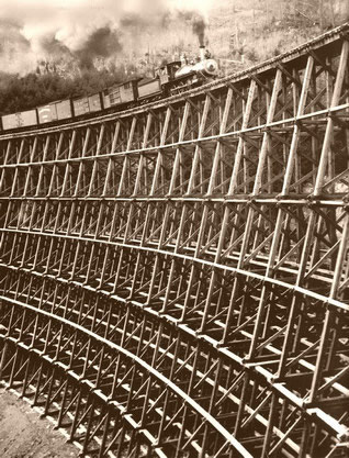
Another industrial relic in Goldstream Park is the E&N Railway trestle that spans Niagara Canyon, one of the largest in Canada. The primary function of the railway, which was completed on 13 August 1886, was to facilitate the destruction of the old growth timber on Vancouver Island. It was part of the 1883 Dunsmuir Land Grab by which a Scottish coal baron engineered the sale of almost one quarter of the Island to private industry.
The original Niagara Canyon Trestle was an enormous timber artifice built from the massive ancient trees readily available from the surrounding forest (right). When part of the trestle was washed out on 12 November 1886 (below), it was replaced with a cantilever bridge built in England.

Niagara Canyon Bridge, c. 1886.
Photo: BC Archives |
|
An additional 35 acres of land in the Goldstream Watershed were removed from the Forest Land Reserve and 180 acres of private forestland on SPAET were sold. To make way for the golf resort, a sacred cave was blown up and bulldozed. This heavy handed abuse of Aboriginal Title and Rights so close to the provincial capital is a continuation of the exploitation that has gone on in the Goldstream Watershed for over one hundred years, leaving a degraded landscape marred by industrial relics such as mine shafts (left).
Niagara Canyon Bridge, c. 1886.
Old postcard
Koksilah River Big Trees There has been little effort to preserve the trestle monuments in BC. As a result, few examples of these powerful symbols of industrial plundering survive. One timber trestle is at Cameron Lake in the Cathedral Grove Watershed and another, the Koksilah Trestle, is not far from Goldstream Park. The ancient indigenous trail north from the mouth of Goldstream River across the sacred Salish Malahat Mountain was converted to a wagon road by settlers in the 1870s. The E&N Railway was built in 1886 following a similar route, and in 1911 a gravel road was constructed, later expanded as part of the TransCanada Highway that bisects and degrades Goldstream Park (below, left). |
|
| |
|
|
|
|
| |
 |

Above: Bear Mt Resort sprawl. Mountain top removal destroying native habitat and cultural heritage in the Goldstream Watershed, 4 January 2009.
Left: Educational signs (graphics added) in Goldstream Park. Note how the TransCanada Highway (red) bisects the Park. The sprawl of Bear Mountain Resort (yellow) has ruined the indigenous land known as "SPAET."
Visitors to Goldstream Park are informed about the cougars and bears who reside in area (left). But there is no mention of how their habitat is being eliminated by unrelenting urban sprawl in the form of subdivisions, roads, malls, hotels, toxic golf courses and so on. |
|
|
| |
|
|
|
|
| |

Bear Mountain Interchange, 2008.
Photo: Ingmar Lee
SPAET An ancient cave was destroyed, together with the forestlands of the Goldstream Watershed that were sacrificed. This was made possible by a sleazy deal when in 2001 the BC government transfered 44 hectares of land to Western Forest Products corp for the giveaway price of one million dollars. Within six months this mountain forestland had been flipped to the Bear Mt Resort developer for the same price and zoning regulations were engineered to facilitate profitable upper market sprawl and polluting golf courses. The coloured contamination that spewed forth from the mountain where once there was pure mineral water was only one of the negative consequences (right). |
|
Bear Mountain Treesit Established in 2006 to protest against the ruination of SPAET (Skirt Mountain) by the voracious Bear Mt Resort corporation. SPAET is part of the Goldstream Watershed, which is most famous for its big trees and salmon. Goldstream Park is a unique instance whereby a rainforest habitat survives close to a urban centre. Yet this ecological jewel had been endangered by a land grab and surreptitious profiteering. Subdividing and developing excesses include road and interchange construction (left).

Sludge from Bear Mt Resort, 2008.
Photo: Ingmar Lee (Click to enlarge) |
|
| |
|
|
|
|
| |
Blasting off mountain tops, destroying aboriginal heritage sites, wiping out the flora and fauna of traditional hunting and forest lands, and destroying rare karst caves seems beyond rationality. Yet this mindless vandalism has been committed at SPAET, unhindered by government oversight or regulations. The loss to the Coast Salish indigenous peoples has been especially tragic (above).
As is often the case in BC, the desecration of aboriginal heritage is one and the same as nature degradation. The Goldstream Watershed, with its rich estuary fishing grounds, has been continually encroached on ever since BC was colonized. Resource extraction was followed by urban sprawl. SPAET, for example, was part of an indigenous hunting and gathering ground reserved for this purpose according to a treaty signed by the governor in 1852.

Big cedar, Goldstream Provincial Park.
Vancouver Island, British Columbia |
|

Big trees, Goldstream Watershed.
Vancouver Island, British Columbia
Every year millions of visitors come to Goldstream River to witness the spectacle of wild salmon struggling upstream to lay their eggs and die at their natal spawning grounds. This remarkable ecological drama is inextricably linked to the big trees and ancient rainforest habitat. |
|
| |
|
|
|
|
| |

Visitor among the ancient trees of Goldstream Provincial Park
Vancouver Island, British Columbia, Canada |
|
| |
|
|
|
|
| |

"Big Trees in Stanley Park, Vancouver BC."
Old postcard |
|
Founded by settlers in the 1860s as a sawmill town, today Vancouver has spread out over the traditional territory of three Coast Salish Peoples – the Musqueam, Tsleil–Watuth and Squamish. Vancouver had a population of 1000 in 1886. When the transcontinental railway arrived in 1888, its population increased to 8,500. In the same year, 1000 acres of mostly logged land was set aside as Stanley Park, named for Lord Stanley, the Governor General of Canada. Some groves of big trees survived as popular attractions (left). |
|
| |
|
|
|
|
| |
Big Trees as Trophies The Vancouver area was originally covered by a temperate rainforest that included some of the largest trees in the world. With the arrival of settlers, and the following massive waves of immigration, the big trees vanished. All that remains today of the grand forests of Douglas firs, red cedar, spruce and hemlock are trophy photos in local archives (right). This photo shows the springboards embedded in the stem of a giant cedar on which two of the fallers are standing. Stumps with such deep springboard scars can be seen in Stanley Park.

Aerial view of Stanley Park, Vancouver.
British Columbia, Canada
Most devastating to the forest ecology was the building of the Lions Gate Bridge from the Stanley Park penninsula to the North Shore in 1937 and the building of a wide Causeway to the bridge that bisected the Park. Mammoth ancient trees that had escaped earlier logging were not spared (right). A plan to build the Causeway underground so as to minimalize the devastation to the forest was rejected as too expensive. Over the years continued recreational encroachments on the Park in the form of golf courses, miniature trains and zoos caused further degradation. |
|

Felling an ancient cedar, Vancouver, c. 1920.
Photo: Archives Canada
Stanley Park is today surrounded by urban sprawl. Where dense forests once provided a wind buffer and protection for the big trees, there are today only concrete and asphalt (left). As a result, powerful Pacific storms and hurricanes have increasingly ravaged the ever vulnerable Park, laying waste to tens of thousands of trees.

Construction of Lions Gate Bridge, 1937.
Photo: North Vancouver Archives |
|
| |
|
|
|
|
| |

Root mass from blown down tree, Stanley Park, 2007.
Vancouver, British Columbia
During the 2006 storm, thousands of trees were blown down in Stanley Park including the cedar tree being photographed by a park visitor as a sawed off stump (right). In 2007 the c. 1,000 year old cedar giant known as the "National Geographic Tree" (below) after it was featured in a 1978 issue of the popular magazine, succumbed and toppled over, its roots no longer able to anchor its mighty stem, measured to have a circumference of 13.5 m (44 ft). |
|
A hurricane force storm in 1962 compelled the Park Board to instigate restoration policies in keeping with the public desire to maintain the wilderness appearance of an intact rainforest. The difficulties of this challenge were demonstrated after another powerful storm on 15 December 2006. Left: a photo taken in Stanley Park after the storm shows the enormous size of the root mass of a toppled over ancient cedar tree and serves as a scale to the fallen arboreal colossus.

Stanley Park, 28 December 2006.
Photo: Richard Lam |
|
| |
|
|
|
|
| |

Construction of Lions Gate Bridge, 1937.
Photo: North Vancouver Archives
Totem Poles Admired Worldwide The history of Stanley Park is marred by the displacement and dispossession of the Coast Salish Peoples: villages were demolished, fishing grounds stolen, ancient middens and burial sites desecrated. Following its questionable legal wins in the 1920s against the people it labelled 'squatters," the City of Vancouver concocted an "Indian Village" as a popular attraction. Only the totem poles (right) were installed. Nearby the BC Lumber Manufacturers Association built a "Lumberman's Arch" in 1952 on the site of the ancient village Whoi Whoi. This was a crude attempt to glorify the industry that had made vast profits from the plundering of the big cedar trees necessary for Northwest Coast art and carving traditions. While the pretentious monument to the deforestation of BC fell into obscurity, the totem poles remain the most popular tourist attraction in BC. In 2008 the Musqueam carver Susan Point erected her huge Coast Salish portals "People Amongst the People" near the totem poles to welcome visitors. These portals mark the first presence of her ancestors on the long contested native site. The artist explains: "The Salish people are finally setting their footprint, their own artwork, on their own land."
|
|
The construction of the Lions Gate Bridge in 1937 and the widening of the Stanley Park Causeway was not just a disaster for the ecology of the already fragmented forest (left), but also wiped out huge swaths of aboriginal heritage. Many of the biggest surviving trees in Stanley Park were located in an extensive archaeological midden, or cultural mound, containing millions of primarily calcined shells. The use of these shells to surface the first roads through Stanley Park destroyed the evidence for longtime aboriginal occupation.
 |
|
Indian Totem Poles, Stanley Park
Vancouver, British Columbia |
|
|
| |
|
|
|
|
| |
The totem pole display in Stanley Park is an example of how the attempt by settler society to appropriate indigenous culture failed. Another instance of failed appropriation is the iconic "Hollow Tree,""The Hollow Tree is synonymous with the towering grandeur of Stanley Park itself and serves as a testament to a time before Western settlement when great untouched giants, hundreds of years old, dominated the entire Coastal area" Stanley Park Hollow Tree Conservation Society.
Given BC's historical identity as a voracious destroyer of big trees, the outpouring of public support for preserving what is essentially a cedar stump is astonishing. The article "Requiem for an ancient cedar," published in Canada's national newspaper, expressed the collective guilt of settler society in BC: "We are pinioned by guilt about global warming and the desecration of our pristine landscapes," wrote Timothy Taylor, "the depletion of our resources and the extinction of species" 7 April 2007, Globe and Mail. |
|
|
|
| |
|
|
|
|
| |

An Insult to First Nations: "BC Spirit Tree,"
BC Canada Pavilion, 2007 Beijing Olympics |
|
Nowhere is the inherent colonial racism of BC more blatant than at Olympic related sites, such as the 2007 BC Canada Pavilion in Beijing, China. Here one of the attractions was a display called the "BC Spirit Tree" (right), fabricated from a 225 year old cedar tree blown down in Stanley Park during the 2006 storm. Both the big tree display and the Pavilion with its huge cedar arches were intended to promote the sale of BC timber in China. A similar "Bella Coola Spirit Tree" was the centrepiece of the BC Canada Pavilion at the 2006 Winter Olympics in Torino, Italy. This distasteful display was a cheap shot at the Bella Coola Indians, an Indigenous People well known in Europe who have long and courageously defended their ancient forests against industrial logging which continues today on their forestlands. Such vulgar commercial "Spirit Trees" insult First Nations by appropriating their respect for the "Tree of Life" to promote the industrial extermination of old growth cedar. |
|
| |
|
|
|
|
| |
 |
Left: "Restoring Nature: Ecology, Memory, and the
Storm History of Vancouver's Stanley Park" by Sean Kheraj. In Canadian
Historical Review, 2007.
"The article argues that there was a dialectical relationship between popular perceptions
of nature in the park and Park Board forest restoration policies that reinforced
the image of the forest as an untouched natural environment." |
 |
Left: "Genealogies of the Land: Aboriginality,
Law, and Territory in Vancouver's Stanley Park"by
Renisa Mawani. In Social and Legal Studies Journal, 2005.
"It is only when
we understand these complexities – of how the colonial past lingers in
the (post) colonial present – that
we can navigate through these juridico-political contradictions and can seek
out social, political, and legal strategies for change."
|
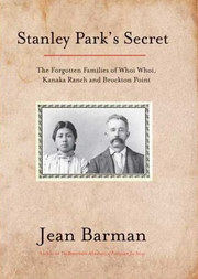 |
Left: "Stanley Park's Secret: The Forgotten Families
of Whoi Whoi, Kanaka Ranch and Brockton Point" by Jean Barman (2005).
According to the author, the creation of Stanley Park was
'a consummately colonial enterprise.' The book exposes the dark and secret
role of the City of Vancouver and its Park Board in denying and concealing
the c. 3,000 year history of aboriginal occupation of Stanley Park. |
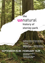 |
Left: "The Unnatural History of Stanley Park." Park
Board poster for an exhibit in English and Chinese celebrating the 120th birthday
of Stanley Park, Vancouver Museum, 2008 - 2009.
"Explore the remarkable
history of this important national treasure [and discover] how natural forces
and human intervention have shaped the park as we know it today" Park
Board.
|
|
|
| |
|
|
|
|
| |
Root mass of a blowdown tree, December 2006.
Stanley Park, Vancouver, British Columbia
Joe Foy of the Wilderness Committee complained that not enough wood had been left in Stanley Park by the loggers and demolition crews. He rightly accused the Park Board of making phoney excuses such as "fire hazard," while urging the commercial sale of the wood to provide restoration funds and to manage invasive species. Not unsurprising, the blowdown trees from Stanley Park were processed at Interfor's Hammond Cedar Mill, a big business that shares a close relationship with the University of British Columbia. The coverup was that the valuable red and yellow old growth cedar planks (right) were used to make 300 canoe paddles to export to Britain as "goodwill Aboriginal gifts." |
|
Despite the knowledge of the social injustice and ecological destruction of Stanley Park (above), the bad policies of the Park Board continue to dominate. For example, after the devastating storm in 2006 (left), a large area of cleared forest was suddenly converted to a parking lot the size of a football field. Ignored was the Stanley Park Ecological Society which had argued that the forest should be left alone to regenerate by natural means. Instead a "management" plan devised by the pro logging Faculty of Forestry at the University of British Columbia was selected.

Cedar from Stanley Park, 2007.
Interfor's Hammond Cedar Mill |
|
| |
|
|
|
|
| |

Big cedar tree, Stanley Park, City of Vancouver, British Columbia, 3 March 2008.
Photo: Tim Farley |
|
| |
|
|
|
|
| |
|
|
| |
©
Credits & Contact |
|
| |
|
|
|
|
|